Pout (Pout)
Pout is a town with commune status in Thiès Department in Thiès Region of Senegal. Its population in 2013 was 23,728. It stands on the side of the N2 road, giving easy access to the large towns of Dakar and Saint-Louis.
The town, in an area traditionally peopled by Sereer, has developed rapidly as a result of industrialisation. It was made a commune de ville in 1990.
Surrounded by forest, it is also a vegetable and fruit growing area where mangos, mandarins and oranges are produced. The industrial activity includes agricultural machine fabrication, salt and cement production and the export offruit and vegetables.
* Partly based on the article in French Wikipedia
Map - Pout (Pout)
Map


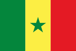
Country - Senegal
 |
 |
| Flag of Senegal | |
Senegal is notably the westernmost country in the mainland of the Old World, or Afro-Eurasia. It owes its name to the Senegal River, which borders it to the east and north. The climate is typically Sahelian, though there is a rainy season. Senegal covers a land area of almost 197000 km2 and has a population of around million. The state is a unitary presidential republic; since the country's foundation in 1960, it has been recognized as one of the most stable countries on the African continent.
Currency / Language
| ISO | Currency | Symbol | Significant figures |
|---|---|---|---|
| XOF | West African CFA franc | Fr | 0 |
| ISO | Language |
|---|---|
| FR | French language |
| WO | Wolof language |